Photos of the Spencer Tornado

Looking ESE from a gravel road, probably a few mi NW of Fulton. Photographer turned south on another gravel road and encountered damage from the first tornado.

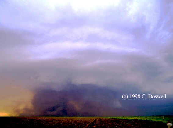
Looking NW from 2 S of Farmer SD

Looking NNW from 2 S of Farmer SD. A digitally enhanced version better defines elements of the tornado's dust cloud.

Looking NNW from 2 S of Farmer SD. A digitally enhanced version better defines elements of the tornado's dust cloud.

Looking N from 2 S of Farmer SD, tornado about to cross Highway 25 in eastern Hanson County. A digitally enhanced version better defines elements of the dust cloud and tail cloud.

Looking NE from 2 S of Farmer SD, tornado between Highway 25 and the Hanson/McCook County line. Note tiered/circular structure to the storm updraft region. RFD dust and poor contrast hide the tornado even in this enhanced version.

Looking WNW from 5 ESE of Spencer SD, tornado between Highway 25 and the Hanson/McCook County line.

Looking WNW from 5 ESE of Spencer SD

Looking W from 4.5 ESE of Spencer SD

Looking W from 4.5 ESE of Spencer SD

Looking W from 4.5 ESE of Spencer SD

Looking W from 4.5 ESE of Spencer SD

Looking W from 4.5 ESE of Spencer SD

Looking W from 4.5 ESE of Spencer SD

Looking W from 4.5 ESE of Spencer SD

Looking W from 4.5 ESE of Spencer SD

Looking W from 4.5 ESE of Spencer SD

Looking W from 4.5 ESE of Spencer SD, tornado near Hanson/McCook County line and approaching Spencer

Looking ENE from 2.5 WSW of Spencer SD, DOW scanning tornado (see nearest DOW images)

Looking NNE from 2 SSW of Spencer SD, tornado entering Spencer. Inflow winds are lifting sand off the sand pile at right.

Looking E from 2.5 WSW of Spencer SD, tornado in Spencer, DOW in foreground

Looking ESE from 1.5 ENE of Farmer SD, .3 to .5 mile wide tornado in Spencer. A digitally enhanced version better defines cloud elements of the tornado.

Looking W from 4.5 ESE of Spencer SD, tornado in Spencer

Looking W from 5 ESE of Spencer SD, tornado in Spencer

Looking W from 5 ESE of Spencer SD, tornado leaving Spencer

Looking E from 2 SSE Farmer SD (Highways 38/25 intersection). Photographer could only see rain wrapping around the mesocyclone. Tornado has become hidden behind precipitation from the western perspective.

Looking W from 5 ESE of Spencer SD, tornado between Spencer and Highway 38

Looking W from 4.5 ESE of Spencer SD, tornado between Spencer and Highway 38

Looking W from 5 ESE of Spencer SD, tornado crossing Highway 38 ESE of Spencer

Looking WSW from 5 ESE of Spencer SD, tornado leaving Highway 38 ESE of Spencer

Looking W from 5 ESE of Spencer SD, tornado leaving Highway 38 ESE of Spencer

Looking W from 4.5 ESE of Spencer SD, multivortex tornado between Highway 38 and I-90

Looking W from ESE of Spencer SD. A 2.14 MB segment of MPEG video by Nick Nicholson was shot from 8 miles S of the (invisible) tornado at the same time as Cheryl's last still image.