For tornado numbers and locations of towns, please refer to this map
of the tornado outbreak, adapted from the NWS Norman's damage surveys. This page is separate from
the SkyPix gallery, and contains both 35 mm still photos and video frame captures
for documentation. All text and images are copyrighted 1999 Roger Edwards. Web design copyrighted 2002 Roger Edwards and Elke Ueblacker. All rights reserved.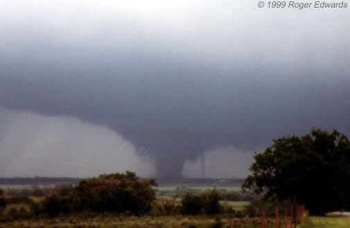
Central Oklahoma Tornado Intercept: 3 May 1999

| Chickasha tornado in its early, wide, diffuse, multivortex phase |  |
Fellow severe-storms meteorologist Rich Thompson and I left Norman at about 4:40 pm, headed SW toward rapid supercell development we noted on visible satellite and radar composite imagery. [I had slept a few hours after a midnight shift; and Rich just got off a daytime mesoscale forecast shift.] The supercell (map, Storm A) formed under a hole in a cirrus plume, just SW of Lawton. It was well-removed from any discernible surface boundaries; the dryline was several counties to the W. [Months later, Rich and I discovered the probable initiator of the storm: a horizontal convective roll. For details, see this conference paper from 2000.] Before we left, we also noted an area of ACCAS (altocumulus castellanus) buildups which were accreting into a surface-based thunderstorm NE of Altus, just E of the dryline and W of our target storm. This would become our second tornadic supercell (map, Storm B). Though the SPC Day-1 outlook had been (correctly) upgraded with each update during the day, from SLGT to MDT to HIGH, and Rich issued a mesoscale discussion alerting to the tornado threat in Oklahoma, several potential pitfalls still remainded in our minds. Storm-relative "anvil-level" flow (approxmated by equilibrium level) was forecast to be weak -- indicating HP (heavy precipitation) storm character; but winds were expected to be much stronger below the EL in the mid/upper levels of the storm envronment. Would the anvil from the western storm seed ours, prodding it toward HP also? The eastern storm wound up fast, producing several tornadoes near Stecker, Cyril and Anadarko (map: tornadoes A1-A5) before we could get to it. We were already hearing awestruck descriptions over the radio by KWTV television storm spotters, still concerned that the storm could go HP, and that we may miss the show if the middle-upper level winds didn't cooperate. Seeding from other storms' anvils, and weaknesses in upper level flow, could allow the storm to recycle precipitation particles, become more precip-efficient, and turn into a giant, amorphously dark HP blob as we had seen many times before. So, on the way down to the storm, pessimism ran rampant that we could possibly see no tornadoes. Little did we know the show was barely starting...and that the most destruction ever visited upon the state of Oklahoma was about to occur. Scientific analysis and observation would give way to amazement, then awe, then the sobering realization of human carnage, frustration...then finally, numb exhaustion. Between Blanchard and Ninnekah, we made a few bad road decisions, but still managed to get within view of the storm's updraft by the time we were E of Ninnekah. Not HP at all -- it was a large, circular, visibly rotating updraft area with very wide separation between the main updraft region and the precipitation of the vault and forward flank regions. Physical concepts of storm-type evolution were being slam-dunked by this rare, spectacular exception! Storm-relative "anvil-level" flow obviously wasn't representing the tremendous downshear precipitation separation and venting which we were observing under the equilibrium level. The seeding influence from other anvils wasn't mattering either, despite our storm's entrapment in the anvil of the one farther W. By the time we could see under the base, W of Ninnekah, there was already a furiously whirling wall cloud; and wispy tendrils of cloud material were beginning to dance along the ground beneath. Tornado! And the first of many to come. The next few hours would give us, by far, the most productive storm intercept ever in our 13 concurrent years of it: the most tornadoes, the greatest variety of tornado shapes and sizes, the most violent and destructive (Bridge Creek, F5 damage, $750 million and counting), and perhaps the biggest (Abell/Mulhall, up to 1.5 miles wide, rivalling Rich's Allison tornado on 8 Jun 1995). The tally: 11 tornadoes, 2 after dark, 2 violent wedges, at least 4 multiple-vortex tornadoes, and 3 separate times when two tornadoes were observed simultaneously. The story will now break down into sections taken from the intercept log, according to tornado chronology.... NOTES:All times are CDT, from tape logs and video subsequently calibrated to Weather Channel time. Vantage locations are plotted on the map, as are paths of the tornadoes themselves.
The satellite tornado emerged as a vertical, narrow, slightly tapered stovepipe to the left (NW-W) of the large tornado. It then widened at the top and narrowed at the bottom -- becoming a tall cone with a small debris fan. The satellite tornado turned S and SE, still moving around the large tornado as the latter disappeared behind trees. Though I uttered "Fujiwara" in video, this was not a true binary, mutually-orbiting vortex: The larger tornado's movement was steady and unperturbed, while the smaller one was clearly the tornado in submissive orbit. Though the satellite tornado did kick up debris, its damage path (which should wind cyclonically NW-SW-S-SE) is almost completely masked by that of the larger and obviously much stronger tornado. Both were moving across open country and doing little structural damage during the satellite tornado's existence. Paul Janish was with us for much of these two tornadoes, as were unknown others. The next time we could see clearly under the meso was looking N and NNW from the S periphery of Chickasha (map: green dot V2) -- and there was no condensation or debris underneath despite very rapid cloud base rotation. During this time, we got stuck in a small chaser-induced traffic jam for a few minutes as the wall cloud loomed to the NNW. Though the cloud-base meso was visually continuous with that of the next tornado, we believe the twin tornadoes themselves to be separate from the next tornado (the Bridge Creek- Moore wedge). NWS damage survey results support this separation near Chickasha. We believed there could be damage in Chickasha, and wanted to avoid being part of another such traffic blockage. We decided to circumnavigate the town to its S and E using unmarked section roads. We also deliberately avoided I-44 with its limited access, concerned the meso could either be cruising right up the freeway or crossing it at an oblique angle with little escape option.
We decided to maneuver NE and were unsure at the time whether this was a separate event from our next tornado sighting. It was. While driving, Jim Leonard was shooting video of this tornado to his SW-WNW beginning near the time we lost sight of it. It narrowed and dissipated 4 W Minco and based on his footage, was a clearly separate event from the next tornado. The next tornado formed from a new occlusion area ~ 2 ESE of the dissipation of the prior tornado to his WNW.
Meanwhile, the better-organized tornado still to our NE narrowed into a cone and faded into the distance. The time given for our last view of it (1958) was probably not its end. Stymied by a police roadblock 2 S Union City on US 81, we had to detour all the way to OK 37 and I-44, then N thru western OKC, before finally catching up with this supercell again after dark near Cashion. In the meantime, we had missed map tornadoes B11-B15 and B17. Storm observing after dark can be very dangerous; but with our combined experience and knowledge of supercell morphology, we felt quite confident we could remain in safe places.
Later DOW analyses by Josh Wurman of OU would show that embedded subvortices of this enormous tornado were larger than the entire Spencer SD tornado of 30 May 1998, which I also witnessed and which a DOW also scanned. Re-analyses of the damage and storm videos by NWS Norman later would combine the Mulhall tornado's path with that of the Perry event on I-35, giving it the longest continuous track of the outbreak. Though we may never know because of a relative lack of substantial structures to damage during much of its path (especially at its largest, SW of Mulhall), it is quite possible that this tornado was at least as violent as the Bridge Creek/Moore F5, despite its F4 damage rating. We briefly attempted to view the next supercell coming NNE out of El Reno -- one which would later produce tornadoes in the area where we were; but poor visibility and the late hour compelled us to head back. I had a midnight shift that night; and it was time to abort the intercept. One of the most unforgettable sensations in my entire life -- much less my history of storm observing -- occurred as we were driving S into northwestern Oklahoma City. The unique and pungent aroma of natural gas, combined with shredded vegetation, became very strong. We realized we were smelling the scent of devastation, carried on warm southeast breezes for 10-15 miles from the Bridge Creek/Moore tornado's swath across the southern OKC metro area. We were blocked by traffic jams on I-35 (the shortest way back) and I-240 (via Sooner Road, the next shortest). We heard that the I-44 route was still open; so we doubled W and came back through Newcastle -- making it back just before the start of my forecast shift. With duty calling, and a dental appointment at 8:30 the next morning, and lingering adrenaline, it would be after 11 a.m. on the 4th before I would fall asleep in an exhausted state of semi-coherence. By then, I was too mentally numb to fully appreciate the enormity of what had happened on our chase, and to the OKC community. We had heard intermittent radio reports of damage and possible casualties in Moore throughout our time with the second supercell; but as we headed back through Oklahoma City toward Norman, those reports grew ever more grim. There were stories of entire subdivisions levelled, houses scoured from the foundations, and body parts found. As storm observers, we must not feel guilty for merely watching them; and we have no control over what they do and where they go. But we must always keep the victim's circumstances in mind. On this night, it was becoming apparent there would be many thousands of them -- over 40 of whom would never again see the light of day, and over 600 more who were physically injured. In days to come, there would be stories of courage and carnage: heroic rescues and gruesome discoveries. A man gathered many of his neighbors into his underground storm cellar before it hit, almost certainly saving some of their lives. Tornado victims able to stand -- some bloodied and battered themselves -- cared for the badly maimed and helped to keep them alive until medics arrived. Emergency rescue personnel and disaster relief workers (from churches, Red Cross, etc.) poured into the area within hours and remained for days, saving lives and offering immediate, much-needed aid. Perhaps the most horrible story among many: One woman stuffed her 11 year old boy into a notch under a bridge along I-44; but with no such space for herself, she held her boy's hand as the tornado engulfed the overpass. As she was losing her grip on the bridge, she told her boy "good-bye" and "I love you;" then let go of his hand as she was blown away to her death. Out of this disaster could come very good things, however, for example: reinforced safe rooms in new homes, greater public awareness and appreciation of severe weather hazards, and scientific discoveries about tornadoes based on the huge volumes of data and images gathered out in the field. This event also teaches important lessons about the science, safety and public policy of severe weather. It is important for those affected by the disaster to know that, in many ways, their deep suffering will not be forgotten and will not be in vain. |
| Chickasha tornado emerges as a dominant cone vortex |  |
|
| Menacing "mothership" storm base with swollen Chickasha tornado centered firmly beneath |  |
|
| Satellite tornado appears to right (NE) of Chickasha tornado |  |
|
| Satellite tornado emerges to left (W) of Chickasha tornado |  |
|
| Chaser jam in Chickasha behind violently rotating, pre-Bridge Creek wall cloud |  |
|
| "Wedge" tornado about to do F5 damage in Bridge Creek |  |
|
| Ft. Cobb tornado under Storm B, as seen from 38 miles away |  |
|
| Brief, diffuse, multivortex Lake Chickasha tornado (Storm B) |  |
|
| Violently rotating wall cloud cuts clear slot just prior to Dutton tornado |  |
|
| Dutton tornado (Storm B) in an early conical stage |  |
|
| Deep zoom of Dutton tornado with multiple vortices |  |
|
| Dutton tornado grows quite large, wall cloud develops inflow tail |  |
|
| Minco tornado early, as a bent cylinder |  |
|
| Minco tornado widens with large subvortices |  |
|
| Anticyclonic flanking-line tornado 15-20 seconds after unroofing a house |  |
|
| Violent Mulhall tornado still enlarging SW of Abell |  |
|
| Wide-angle of 1/2 mile wide Mulhall tornado under 10 mile wide updraft base SW of Abell |  |
|
| Power flash within violent Mulhall tornado, now nearly 1.5 miles wide between Abell and Mulhall |  |
|
|
|
||
My personal Editorial Comments from this tornado event (from 2002)
Formal research paper on the outbreak by Thompson & Edwards (Dec. 2000 Weather and Forecasting)
Formal research paper on the outbreak by Edwards et al. (June 2002 Weather and Forecasting)
Satellite images and loops from Scott Bachmeier
Outstanding radar images of the supercells from NWS OUN
Large radar-image set from Travis Smith
Was Storm A initiated by a horizontal convective roll?
NOAA Service Assessment in PDF format.
[The synoptic overview and weather map are grossly oversimplified and erroneous; but several of the recommendations (e.g., unsafe shelter under bridges) are right on target.]
V.O.R.T.EX.-99 field messages during the outbreak
More information may be added as it becomes available.